Sommaire
The Tre Cime Di Lavaredo Hike
I dreamed of going back to the Dolomites since I quickly traveled there one year ago. Among the long list of incredible landscapes to discover in Dolomites, the Tre Cime Di Lavaredo were obviously among the TOP 3 of the hikes to do. Why are they so famous in Italy ? The Tre Cime di Lavaredo are one of the emblems of the Dolomites, three very characteristic mountains that surprise with their unique and masterful shapes and offer a breathtaking view of the surrounding landscape and the lakes along the way.
History of the Tre Cime Di Lavaredo
The Tre Cime Natural Park is located on the border between the Trentino Alto Adige region (South Tyrol) and Veneto in Northern Italy. This area was the scene of many clashes during the First World War between the Austro-Hungarian and Italian empires, as evidenced by some of the remnants of past clashes (see the Monte Piana hike in particular, where the historical route was impressive).
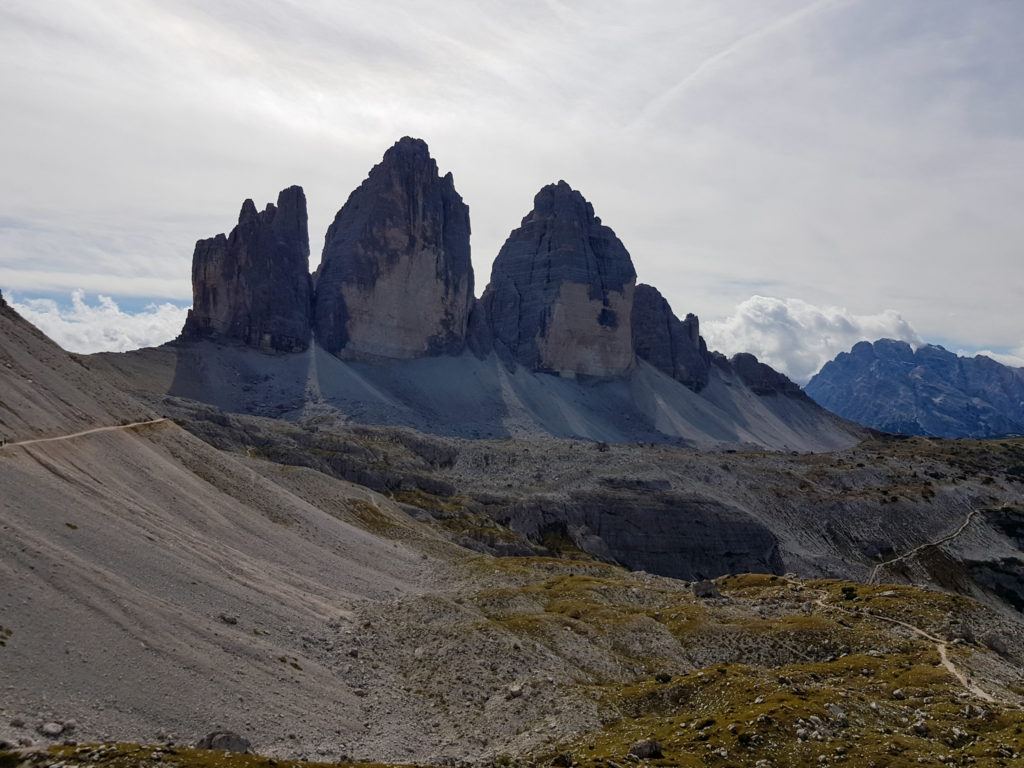
The Tre Cime di Lavaredo massif is composed of 3 distinct peaks: the Cima Grande, the “big peak” with a height of 2999 meters, the Cima Piccola, the “small peak” (2857 meters) and the Cima Ovest, the “western peak” (2973 meters).
Disclaimer : English is not my mother language, I do my best to translate my article from french to english. If there is an error, feel free to let a commentary or to send me a message. Thanks a lot.
Why are the Tre Cime Di Lavaredo Regional Stars?
That’s the question! Why one mountain rather than another and these in particular… If the mountains of the Tre Cime Di Lavaredo have a very particular relief and shape, I would say that it is above all the breathtaking setting of the massif that has impressed me the most. The surrounding landscape is incredible and really worth the detour. Even if, I would speak about it after, the crowd and the over-touristic aspect “spoils” the picture a bit.
To come back to the three stars, icons of the Dolomites, their beauty does not leave any marble, or rather clay since the walls are composed of a mixture of clay and dolomitic limestone. Majestic, fine and almost seemingly hand-cut.
The Disneyland of Hiking
We didn’t really organise or hike to the Tre Cime Di Lavaredo, to be honest. We just say ” ok, let’s go see the Tre Cime”. I had slightly omitted to read the hiking guides and the well informed websites… in which case I would certainly have understood from the start that it would not be a hike far from everything and in deep reconnection with nature… so, it’s hard to complain when you find yourself in front of a xxl size parking lot, after having paid a 30€ toll, watching the buses of tourists arrive.
After this little moment of panic “I’m really going to do a hike with people in front of me and people behind me” and this feeling of reliving some dark hours of crowded trailrunning races, I was relieved to notice that by taking more difficult and longer paths I quickly found the peace of deserted landscapes. Phew.
So yes, you have to expect to see a lot of people on this Tre Cime Di Lavaredo hike and to feel more like a “tourist” than a hiker. But the landscapes and the route are really worth it.
Solitude Belongs To Those Who Get Up Early?
My advice is mixed on this… Yes, the more the alarm clock goes off, the more you will be alone to admire the three peaks. That’s a fact. Afterwards, if they are in the clouds, and not clear (which was the case around 10 am when we arrived) you will have just shortened your night to admire a white cottony heap.
The Tre Cime Di Lavaredo Journey
The massif offers many possibilities and allows everyone to find what they are looking for… from the less experienced hikers who simply want to admire the Tre Cime and enjoy a breathtaking view, to the more athletic ones who want to warm up their thighs.
This is still a mountain route and therefore requires the right equipment and organization, especially in case of weather changes. The difference in altitude is quite small if you just go around the Tre Cime, but it can quickly increase the further you go and if you prefer more protected routes to the “classic” path. There are many refuges to refuel, but no free water fountains to fill your gourd it seems to me.
Region: Dolomites, Italy
Distance: variable depending on the route. There are many itineraries that allow you to cover more or less kilometers and altitude differences. In this article the itinerary I present is about 14 kms, but it is possible to lengthen or shorten it according to the weather, the physical form…
Altitude: The starting point, the Auronzo refuge, is located at 2,320 meters above sea level. The highest point of the hike that we did is at 2,525 meters above sea level.
Difficulties: no difficulty and a well cleared route, very easy for hikers and used to the mountains, be careful for the others not to underestimate the equipment!
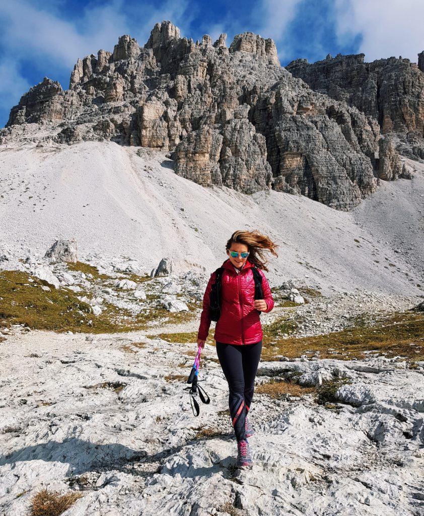
Equipment and gear: the equipment and gear to bring really depend on your program of the day… Go for a short and not very committed hike to go around the Tre Cime, lengthen the kilometers and the difference in altitude by taking steeper paths… or take advantage of the via ferrata. For the first option the path is very easy, not very uneven and the simple tour of the Tre Cime requires a basic equipment without needing to spend a lot of money at Decathlon. Be careful to take hiking boots and an “onion” equipment that allows you to strip off if necessary. At more than 2 000m of altitude you can easily switch from down jacket to T-shirt depending on the wind, the sun and so on… I personally spent 4 hours taking off and putting back on my clothes.
Take water, even if there are many refuges on the way. Concerning the sticks, it will also depend on the program of the day…and your physical condition. For the “small tour”, they are not really necessary. For longer tours, they can be useful for some climbs and practical for the descents.
Signposting: it is impossible to get lost. Signs or painted indications every 100 meters…many well detailed maps. Even if you’re not familiar with orientation, you don’t need to worry.
Duration : plan a whole day !
HOW TO GET TO THE TRE CIME?
We were coming from Dobbiaco, the last big town before entering the Tre Cime Natural Park. The day before, we had done the Monte Piana hike, which offered a breathtaking view of the Tre Cime and was much less, much less, used than the Tre Cime route (and less expensive too, but that’s another subject).
From Dobbiaco, after having walked along the Lago di Lando, it is impossible to miss the Tre Cime…which are indicated many kilometers in advance.
To get to the Tre Cime there are then several options depending on your choice of organization, time…
Option 1. The path passes through Misurina, the last village before entering the Tre Cime site. It is possible to sleep there (hotels, campsites and camping car sites), to eat there with several restaurants, to do some shopping with a mini supermarket or even to take advantage of free public toilets (hallelujah), well ok Turkish toilets but free toilets in the dolomites is a fact rare enough to be celebrated. I said option 1, it is possible to leave your car in Misurina and take the bus.
Option 2: We go up again a little after Misurina, continuing on the main road SP49. We cross some bus stops on the road and some hikers. Arrived in front of the toll, we realize that to go to the immense parking of the Refuge Auronzo it is necessary to pay not less than 30 euros by car. Yes yes, you read well… 30€ to park on a parking lot, in the middle of nature… and to say that the Parisian parking lots seemed to me out of price. Anyway, option 2 is possible to leave your car (or your motorcycle, your caravan) before the toll and take the bus or walk up. You just have to take the path parallel to the road and which also arrives at the refuge of Auronzo…be careful the ascent stings a little (in any case it seemed rather prickly from my car seat) and will take at least 2 hours depending on the form (you have to plan the outward journey and the return journey accordingly).
Option 3. Accept the pain, quickly digest the 30€ parking fee and tell yourself that it’s what…3 mojitos, and go to the huge parking lot next to the Auronzo refuge.
Unfortunately, this is the option we had to take… because of the lack of time since we had a short time to go up and down. We also lacked information because we had not read before that it was possible to take buses to go up. If I had to do it again (with ifs, we would save so many parking spaces) I think I would walk up. More on principle because I don’t really like feeling like a pigeon when I’m just going for a hike. But I would only recommend this option to people who can hike for several hours and climb for a while, otherwise they will be already tired at the top and won’t enjoy the amazing landscapes.
Nb: It is possible to reach the Tre Cime by other itineraries much longer and with a more sustained difference in altitude, starting from the surrounding valleys.
Tre Cime Di Lavaredo Hiking Path
It’s time to go, isn’t it? Even if I repeat it the path is very well marked I propose you below the route that we took…in order not to miss these superb points of view. As indicated above it is very easily possible to lengthen or shorten to see more or less landscapes, and to take advantage of the many points of restoring that the refuges of the massif propose.
Our Itinerary In Summary, For those in a hurry :
14KM – 760 D+.
Way 101 / Departure from the Auronzo hut with all our friends the tourist buses (smile).
Way 104 / After the Lavaredo refuge, fork to the right to say goodbye to the company and find the peace of the mountains. I should point out that we did this hike in September, on a Thursday. I do not guarantee absolute solitude on this route !
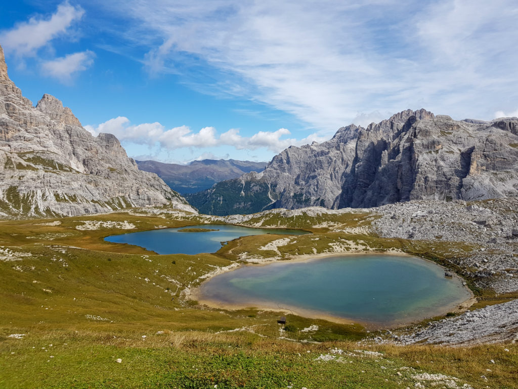
Way 101 / Which goes down slightly, then goes up to the Locatelli refuge enjoying a magnificent view on several lakes.
Way 105 / Descent to Piano di Rienza and climb to the Col Forcellina, where is Lange Alm.Tour of the Tre Cime to return to the parking lot.
In Detail And In Photo :
Way 101 / Departure from the Auronzo refuge, take the direction of the Lavaredo Refuge by leaving on the large open track that is behind the refuge. No difficulty at this level, the path is flat and very easy. It goes along the south face of the Tre Cime to Piano di Lavaredo, and allows to admire the pretty little Chapel of Santa Maria Ausiliatrice.
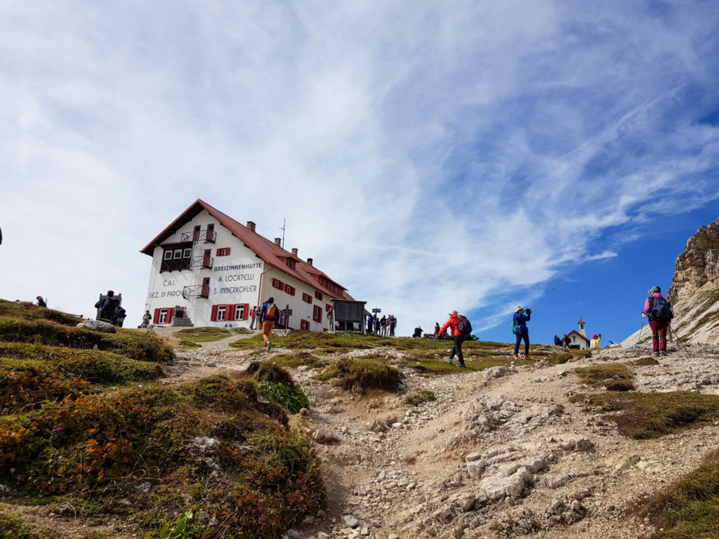
Way 101 / The main trail continues until the Lavaredo Refuge (Rifugio di Lavaredo), where the flow of hikers goes to the left to reach the Forcella di Lavaredo and then the Locatelli refuge and where I suggest you to find the calm of the mountains and to take the right. Don’t panic, we will find the Locatelli hut later.
Way 104 / We leave then the road 101 to find ourselves on the 104, with the same sensation of happiness that to take a cut-file in Disney. Finished the tourists, hello freedom. And the unevenness!
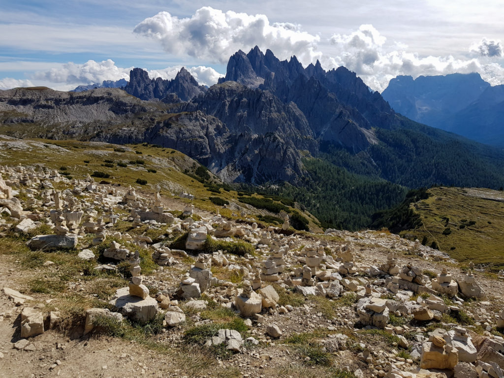
A bit of a descent to start with and along the Lago di Cengia then a nice climb that leads to a superb viewpoint: Forcella Pian di Cengia, the high point of the hike (and a point where having a windbreaker or a down jacket can be useful). From there we made a small detour to the right to see the Pian di Cengia Refuge (number 4) at 2,525m and then retraced our steps to take the descent to the lake.
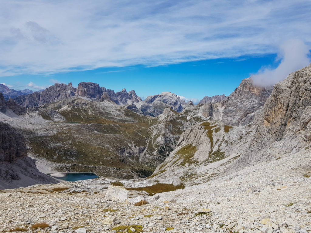
Way 101 / Descent a little technical, offering great views, which leads to a first beautiful lake and along the Laghi dei Piani.
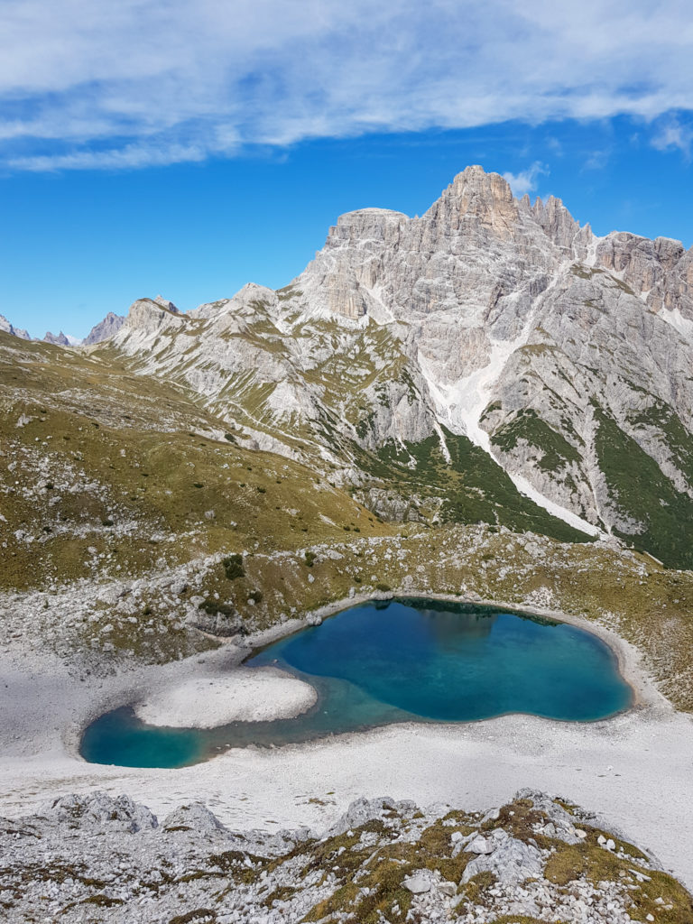
The path remains quite simple and well laid out, still less used than the main accesses.
Arrived at the Refuge Antonio Locatelli, we find there a lot of people.
At this point, to reach the parking of the Lavaredo Refuge it is possible :
- to take the path on the left to get back to the Lavaredo Refuge crossroads, passing through the Forcella di Lavaredo.
- to go around the Tre Cime on the other side, taking the path 105 to go to the Lange Alm refuge. This is the option we chose in order to see the other side of the Tre Cime.
Path 105/ The descent from the Rifugio Antonio Locatelli is quite easy, a staircase allows to cross the rocky bar. Then you go down to the Piano di Rienza to go up to the Col Forcellina. The ascent is not difficult but it is a bit of a hike.
At the refuge of Lange Alm, it is also possible to stop, to enjoy the magnificent view on the Tre Cime and then to continue straight on towards the return! The parking lot is not far away and the last kilometers still offer beautiful views!
I hope you will enjoy this hike! Don’t hesitate to send me feedback or pictures to complete this article!