Cyclone Mocha could reach the Category 4 storm level when it makes landfall, with wind speeds of more than 130 miles per hour like Cyclone Nargis, announced the Global Disaster Alert and Coordination System (GDACS) on the morning of May 12.
On May 12, Mocha's level was Category 1, and on May 14, it will reach into Category 4. GDACS predicted that the storm's wind speed would reach 222 km/h (137 mph).
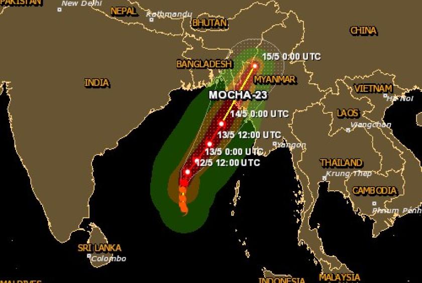
Bangladesh and India have joined the countries that will be affected by the storm, while previously only Myanmar was the only country.
However, Myanmar is at the top of the list of population that will be affected, with more than 970,000 people in Rakhine State, 600,000 people in Sagaing Region and 120,000 people in Magwe Region and 360,000 people in Chin State, reported the GDACS.
More than 250,000 people in Chittagong, Bangladesh and about 45,000 people from Indian state of Mizoram will be affected by the storm.
The Department of Meteorology and Hydrology (DMH) of Myanmar has announced that the Mocha storm has reached a very strong cyclonic storm as measured on May 12 and has arrived 495 nautical miles away from Sittway.
The central pressure of the cyclone Mocha is 988 hPa and the maximum wind speed is about 75 to 85 mph, the DMH said.
The DMH predicted that the storm will make landfall near Sittway on May 14, and the wind speed may exceed 100 mph in Rakhine State.
U Win Naing, a meteorologist, quoting JTWC, an American weather station, and wrote on his social network that the Mocha suddenly strengthened and the storm's path did not change significantly and damage could occur due to the large size of the storm.
"On the morning of May 12, when JTWC's Warning-5 was issued, we could see that the "RI situation" (Rapid Intensification) that we had worried about the previous days could happen. When Cyclone Mocha reached about 280 miles southwest of Sittway at 6:30 pm on May 13, the storm's wind speed increased to 105 knots - 120 miles per hour. It continued to move northeast and the storm's center wind speed increased to 120 knots - 138 miles per hour at 6:30 am on May 14 when it reached 140 miles southwest of Sittway. It is possible to reach the CAT-3 level of the cyclone. The storm track has not changed significantly, but it has moved up to about 30 miles north of the JTWC forecast track seen yesterday. It appears that it will make landfall between "Kyaukpanu" and "Indin" villages located between Sittway and Maungdaw. According to today's latest forecast - Cyclone Mocha's land-locked track has moved up to about 30 miles, but the storm's size and intensity could cause major damage along Myanmar's western coast. The ECMWF model predicts that the storm's center, which is about 140 miles southwest of Sittway City with wind speeds of up to 138 miles per hour, will have waves up to 38 feet. Coastal residents and local responsible organizations that will carry out evacuation operations have been notified,” he wrote.
The storm, like Nargis, will have wind speeds of more than 130 miles per hour when it enters the land, and it will be necessary to make preparations as the weather department releases forecasts.
The map of the storm's path published by the Myanmar Information Management Unit (MIMU) reported that strong winds will blow at 120 kilometers per hour in some townships of Rakhine State, Chin State and Sagaing Region. In the cities which the storm will pass through are Sittway, Yathedaung, Myebon, Minbya, Ponnagyun, Pauktaw, MraukU, Saw, Kanpetlet, Yinmabin, Kani, Kyauktu and Gangaw. Among the cities that will be hit by winds of 90 kilometers per hour are Manaung, Laytaung, An and Kyaukpyu in Rakhine State, Seikpyukyun, Pwintbyu, Salin and Myitchey in Magway Region.
Cyclone Nargis, the worst and most destructive cyclone in Myanmar, had a maximum wind speed of 130 miles per hour. Nargis has turned into a powerful cyclone within a week, counting from the low pressure process that would have caused the storm.
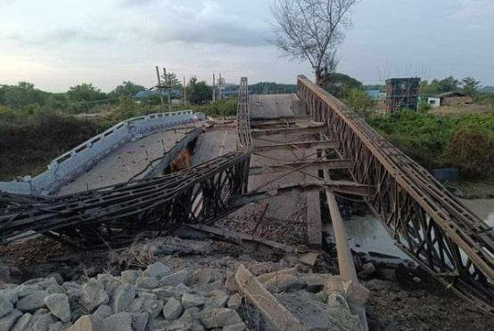
The low pressure area that would cause Cyclone Nargis to form began on April 27, 2008, and transformed into a storm on May 1. The storm entered Myanmar on May 2, 2008, and entered the Ayeyawady delta region for about 40 kilometers, causing massive damage and killing hundreds of thousands of people. The value of the damage was more than 62.988 billion kyats (US$10 billion), and it was recorded as one of the most damaging storms among the storms that occurred in the North Indian Ocean.
Cyclone Nargis was originally predicted to hit Bangladesh or Southeast India, but later changed its course and entered the delta region of Myanmar. Countries such as Myanmar, India, Bangladesh and Sri Lanka were affected by the storm, and Myanmar experienced the worst situation.
Currently, the very severe cyclonic storm Mocha will enter the inland area towards Sittway, Rakhine State, and areas such as Magway and Sagaing regions will also be affected by the storm.
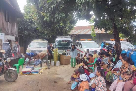
These areas currently lack regional stability and there are people fleeing the war.
The fighting in Rakhine State has been going on for more than three years and continued until the end of 2022. Even though the area is still stable, if such a strong storm hits, many local people are likely to face great difficulties.
Similarly, locals from Magway, Sagaing regions and Chin State are fleeing from their home due to the fighting and instability. It is also a time to face social problems and difficulties.
In such situations, when a strong storm like Nargis will hit, it will be a situation where humanitarian assistance will be urgently needed, and the international community may have difficulties in providing humanitarian assistance.
Currently, according to the forecasts of the world meteorological organizations and the DMH, Mocha is predicted to be as strong as Nargis, and before it makes landfall, people must carefully monitor its changes on May 13 and 14.