Pedersöre Church
Pedersöre Church is a medieval stone church in Jakobstad. It is one of the oldest medieval churches in Ostrobothnia. The site of the first wooden church was built in the late 1200s.Photo: Tomisti, CC BY-SA 3.0.
- Type: Church
- Denomination: Lutheran
- Description: church in Jakobstad, Finland
- Address: Vasavägen, Jakobstad, 68600
Notable Places in the Area
Kristallen
Sports venue

Photo: Pyhajumbo, CC BY-SA 2.5.
Kristallen is a sports venue situated 410 metres north of Pedersöre Church.
Jakobstad City Hall
Town hall
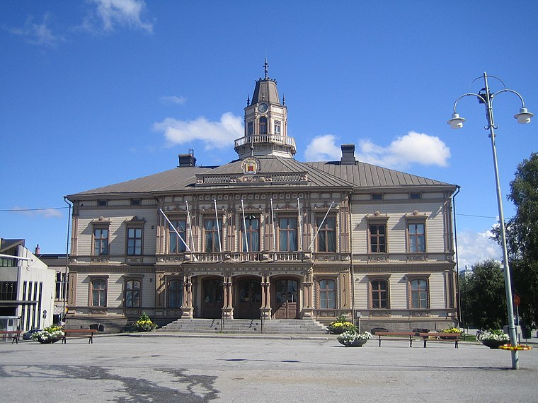
Photo: Tomisti, CC BY-SA 3.0.
Jakobstad City Hall is a historic building in the city of Jakobstad, Finland. Jakobstad City Hall is situated 1¼ km north of Pedersöre Church.
Jakobstad Church
Church
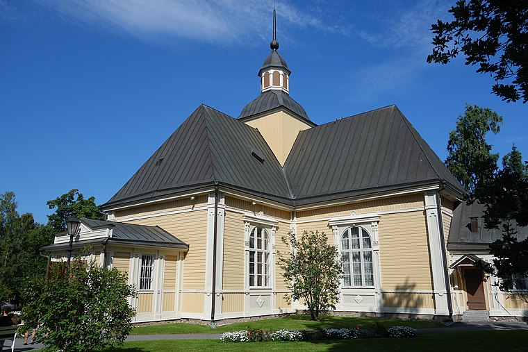
Photo: Asbjørn, CC BY-SA 3.0.
Jakobstad Church is a Lutheran church in the city of Jakobstad, Finland. Jakobstad Church is situated 1½ km north of Pedersöre Church.
Localities in the Area
Bennäs
Town

Photo: Tomisti, CC BY-SA 3.0.
Bennäs is a village, urban area and railway station in the municipality of Pedersöre, Finland. Bennäs is situated 8 km southeast of Pedersöre Church.
Pedersöre Church
- Categories: place of worship and religion
- Location: Jakobstad, Jakobstadsregionen, Ostrobothnia, West Coast, Finland, Nordic countries, Europe
- View on OpenStreetMap
Latitude
63.66425° or 63° 39' 51" northLongitude
22.70062° or 22° 42' 2" eastOpen Location Code
9GM4MP72+M6OpenStreetMap ID
node 385601649OpenStreetMap Feature
amenity=place_of_worshipOpenStreetMap Attribute
denomination=lutheranWikidata ID
Q7159141Pedersöre Church Satellite Map
© OpenStreetMap, Mapbox and Maxar
Also Known As
- English: Pedersöre kyrka
- English: Pedersören kirkko
- Finnish: Pedersören kirkko
- German: Pedersöre Kirche
- Swedish: Pedersöre kyrka
- Swedish: Pedersören kirkko
Landmarks in the Area
- sankarihautausmaaChurchyard
- Kyrkostrands församlingshemChurch
- Fitness Club490 metres northeast
- Jehovan Todistajain ValtakunnansaliChurch, 610 metres west
- Lapinnevan LeikkipuistoPlayground, 630 metres southwest
Places in the Area
- SankariristiMemorial
- Kyrkostrands daghemKindergarten, 340 metres southwest
- K-SupermarketSupermarket, 370 metres northeast
- SpråkbadsskolanSchool, 440 metres north
- Neste Oil, SödratullenGas station, 490 metres north
Popular Destinations in Ostrobothnia
Discover Vaasa, Kaskinen, Kristinestad and Närpes.
Escape to a Random Place
Discover other churches in the world.
About Mapcarta. Thanks to Mapbox for providing amazing maps. Data © OpenStreetMap contributors and available under the Open Database License. Text is available under the CC BY-SA 4.0 license, excluding photos, directions and the map. Description text is based on the Wikipdia page Pedersöre Church. Photo: Tomisti, CC BY-SA 3.0.