Share

Scan the QR code and open PeakVisor on your phone
Scan the QR code and open PeakVisor on your phone
The Karelides are the largest mountain range in Finland and one of the oldest collections of mountains in Europe. They are much older than the Alps and they used to be just as high. Despite their current modest size, the Karelides offer many great opportunities for outdoor activities such as hiking, skiing, and kayaking, among others. There are 1450 named mountains in the Karelides, the highest and most prominent of which is Taivaskero (809 m / 2,654 ft).

The name of the Karelides comes from the name of the historical, geographical, and cultural region of Karelia, which is one of the regions where the range is located. Nowadays, the broader cultural region of Karelia is administratively divided into North Karelia and South Karelia in Finland and the Republic of Karelia in Russia.
In turn, the name of the region of Karelia comes from the people who inhabit it—the Karelians. The Karelians call their homeland Karjala.
The origin of the word Karelia itself is unclear but it’s believed that Karjala shares a similar etymology as the modern Finnish karja, which means ‘herd.’ This may be a reference to animal husbandry, a common method of subsistence in this region for thousands of years.
The Finnish name for the mountain range is Karelidit. In Swedish, it is called Kareliderna and in Russian, it is called Karelidy (Карелиды).

The Karelides are found throughout most of Finland. In other words, all of those relatively low rocks, cliffs, and boulders that are strewn among the Finnish lakes as well as the hills and fells of Lapland are actually part of the Karelides. It’s impossible to really imagine the bulk of the Finnish landscape without picturing the hills of the Karelides.
And yet, these mountains are not found everywhere in Finland. They are located mostly in the eastern and northern parts of the country. They extend from the Finnish Lakeland in the southeast and they run along the entire eastern border with Russia and Norway all the way to Lapland, where they dominate the landscape.
The Karelian Mountains give way to the Scandinavian Mountains only in the extreme northwestern part of the country. Furthermore, the extreme northern part of Finland is technically home to the mountains of the Kola Domain, rather than the hills of the Karelides.
On a political map of Finland, the Karelides can be found in the following regions of the country:

The Karelides are primarily associated with Finland, but it’s worth noting that the mountains in the territory of the Republic of Karelia in Russia are also referred to as the Karelides, too.
To get to the Karelides, you can travel from Helsinki in Finland to the capital of South Karelia, Lappeenranta, or the capital of North Karelia, Joensuu.
You can also get to these two cities from St. Petersburg in Russia. The overall distance from either Helsinki or St. Petersburg to these cities is around 200–300 km (124–186 mi). From Karelia, you can easily travel northward through Finland to see the rest of the Karelides.
If you are interested in visiting the Karelides of Lapland rather than the hills of Lakeland, your best bet is to travel directly to Rovaniemi, which is the capital of the northernmost region of the country. This can be done either by car, train or bus or by direct flight from Helsinki. An alternative option is to fly to the small but busy airport in Ivalo in the eastern part of Lapland.

Geologically, the Karelides belong to the Karelian Domain, one of the major geological strata in Finland and neighboring countries.
The other major geologic formations in the region are the Scandinavian Caledonides (Scandinavian Mountains) in Norway and Sweden; the Kola Domain, including the Lapland Granulite Belt and Inari Complex in Norway and Russia; and the Svecofennian orogen (Svecofennides) in Southern Finland and Sweden.
All of these geologic formations as well as the entire territory of Scandinavia belong to the Baltic Shield, a segment of the Earth’s crust that is 1.5 to 3 billion years old. The Karelides themselves formed about 2 billion years ago.
The main rocks of Karelides are various kinds of granite, including rapakivi granite, which is locally famous for its reddish color, and the Jotnian sediments, which encompass different shales, siltstones, conglomerates, and sandstones. There are also gneisses, quartzites, dolomites, and diabases found in the range.
Furthermore, the Karelides are home to a few relatively rare rocks, such as shungite (graphitized coal). Shungite is the symbol of the Russian region of Karelia and it can be found in various parts of the range.
Moreover, the Karelian Domain is the oldest part of the Baltic Shield, as it dates back to the Archean (4 to 2.5 billion years ago) and Paleoproterozoic (2.5 to 1.6 billion years ago) ages. So these mountains are much older than the Alps, which started to form between 300 million years ago as a result of the collision of the African and European tectonic plates.

The Karelides also formed as a result of long geological processes in the Earth, including fractures in the Earth’s crust and the superposition of layers. As a result of these processes, it’s believed that the Karelides once reached the height of the Alps.
However, the Karelides were eventually eroded down and they lost much of their lofty height. This weathering and erosion occurred for many reasons, though billions of years of exposure to wind and water can grind away at the surface of even the mightiest of mountain ranges.
One of the biggest causes of erosion in the region was the most recent glaciation. The massive glaciers and ice sheets that once covered much of northern Europe carved out the many valleys that we see in the region today. They also smoothed over the rugged peaks of the region, leaving behind rounded hills and a much more gentle topography.
As a result of all this erosion, the Karelides, which were once among the highest peaks in Europe, turned into a relatively flat plain with only the occasional rolling hill. Over time, the same fate will befall the other high mountains on our planet Earth.

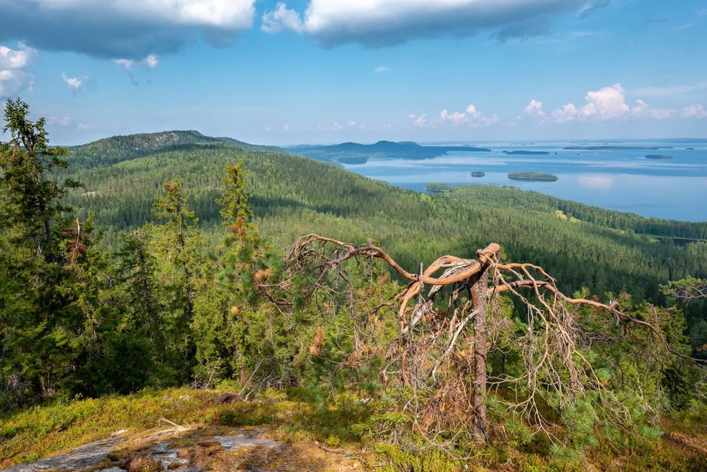
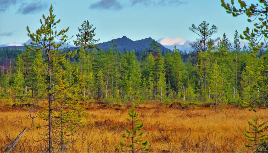
The Karelides are a collection of relatively low-lying hills that range in height from a few hundred meters in their southern part to 800 m (2,624 feet) in the north.
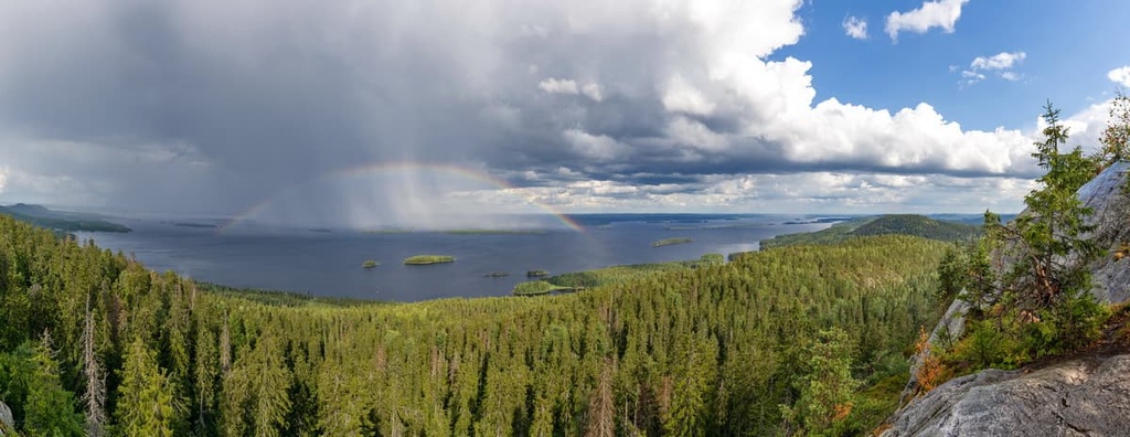
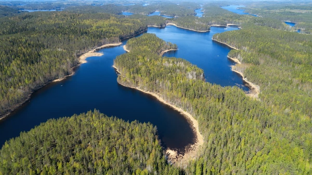
However, the low elevation of these mountains is offset by the region’s incredibly scenic landscapes. Some of the most notable landscapes in the region include the lakes and forests of Lakeland, the agricultural fields and meadows with wooden cottages and farms of central Finland, and the vast areas of the Arctic tundra in the northern part of the country.
Also, in my experience of hiking and climbing the Karelides, a vantage point of even 200–300 m (656–ft) is enough to experience magnificent panoramic views in the region. Plus, thanks to the many rocks and boulders that are scattered here and there throughout the Finnish forests, hiking deep in the woods of the Karelides is also very interesting as the scenery is constantly changing.
Another special feature of the local landscape is the rocks that are located on the shores of the region’s lakes that form smooth vertical walls that drop straight into the water. You can only see them from the water by boat. These places were historically very important to people who lived in the area, as is evidenced by the rock paintings and petroglyphs found on many of these cliffs that are up to 4,000–5,000 years old.

Finally, at least 12 of the 27 national landscapes of Finland can be found in these mountains. These include:
The Karelides do not have definite subdivisions and subranges like what we see in the Alps and other major mountain ranges. However, it is customary to distinguish several areas within the Karelides that contain unique groups of summits and individual interesting mountains.
Here is a list of more than 10 major areas and peaks of the Karelides and their features that you can find as you move from south to north in the range.
Haukkavuori (173 m / 567 ft) is the highest peak in the South Karelia region. It is known as one of the historical markers that once distinguished the boundary between the Kingdom of Sweden and the Novgorod Republic.
In fact, the peak is mentioned in the Treaty of Nöteborg—the first peace treaty to establish borders between the two countries. It was signed on August 12, 1323, after 30 years of war.
Ukko-Koli (346 m / 1,138 ft), and its two neighbors, Akka-Koli (338 m / 1,109 ft), and Paha-Koli (331 m / 1,086 ft), are a group of three peaks in Koli National Park in the Lakeland region and North Karelia.

They are probably the best-known peaks of the Karelides, despite their low height. Nevertheless, they are the most recognizable and highest mountains in all of southern Finland.
Runeberg Hill or Runeberg Mound (25 m / 82 ft) is the highest point of Punkaharju Esker Ridge, the most famous natural landmark in the South Savo region and one of the most recognizable in Finland as a whole. The mountain is named after a famous Finnish poet, Johan Ludvig Runeberg.
Ukonvuori (143 m / 469 ft) is a mountain located in Kolovesi National Park. It is famous for being home to rock drawings that are around 5,000 years old, though it is far from the only such archaeological site in the region.

Neitvuori (184 m / 603 ft) is the second-highest peak in the region of Southern Savonia, and it is also the most famous. The peak is called the “Switzerland of Savo” because of the views that it offers of the Saimaa Lake System from its summit.
Puijo (232 m / 761 ft) is the eighth-highest mountain in the North Savo. However, it is arguably the most famous mountain in the region because it is located almost in the center of Kuopio, the regional capital. It is also the most popular recreation area and viewpoint in the region.

Morgam-Viipus (603 m / 1,978 ft) is the highest point in the entire municipality of Inari, which is the largest in Finland by total land area. Inari is also the capital of the Sámi, the Indigenous people of Lapland, so Morgam-Viipus also holds cultural significance in the region.
Sokosti (718 m / 2,355 ft) is the highest peak in Maanselkä, a relatively small mountain area that’s located in northeastern Lapland as well as in parts of the northern Republic of Karelia in Russia and Norway. It is also the highest peak of Urho Kekkonen National Park.

Korvatunturi (486 m / 1,594 ft) is another great mountain in the Urho Kekkonen National Park. According to legend, the Finnish Santa Claus lives on Korvatunturi.
You can climb the mountain, but only with permission from the border service because the peak is located on Finland’s border with Russia.

Pallastunturi is a group of seven relatively high fells in Pallas-Yllästunturi National Park. It is also one of the most popular places in the Karelides mountains among visitors, due to the fact that it is on the list of the 27 nationally significant landscapes of Finland.
The fells of Pallastunturi are:

Taivaskero (809 m / 2,654 ft) is technically part of Pallastunturi but it is worth mentioning separately. It is the highest peak in Pallas-Yllästunturi National Park and the most prominent in Lapland (509 m / 1670 ft).
The mountain is also known for the fact that the Olympic flame for the Summer Olympics in Helsinki in 1952 was lit on its slopes using the rays of the midnight sun. It’s worth noting that this was the second Olympic flame for the 1952 Games as the first flame was lit in Olympia, Greece. The two flames were combined at the town of Tornio and they were carried as one flame until the end of the relay at Helsinki.

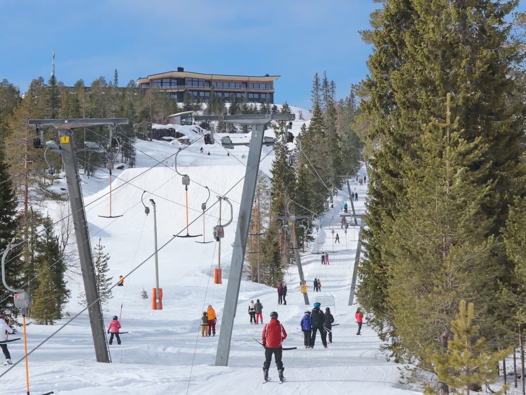
Yllästunturi (719 m / 2,358 ft) is also located in Pallas-Yllästunturi National Park and it is one of the park’s namesakes. The second-largest ski resort in Finland, Ylläs, is located on Yllästunturi.

Given the fact that the Karelides extend over most of Finland, there are more than 50 different hiking areas in this mountain range, which can be divided into five large groups: national parks, nature reserves, wilderness areas, other areas, and individual points of interest, including nature centers.
You can learn about the many national parks, nature reserves, and wilderness areas in the Karelides in the specific PeakVisor articles for each of those places. In the interest of providing you with novel information about hiking in the range, this article will focus primarily on less touristy areas and trails that you might not hear about elsewhere.
With that in mind, here are some of the best places to go hiking in the Karelides.
There are only a handful of lesser-known hiking areas in the Karelides of South Savo, such as Saimaa Nature Centre “Riihisaari.”
Another hiking area you can visit is the Punkaharju Nature Reserve, which features 5.3 km (3.2 mi) of hiking trails and 7.5 km (4.6 mi) of cross-country skiing trails.

Good hiking areas to check out in North Karelia include the Koli Nature Centre “Ukko.”
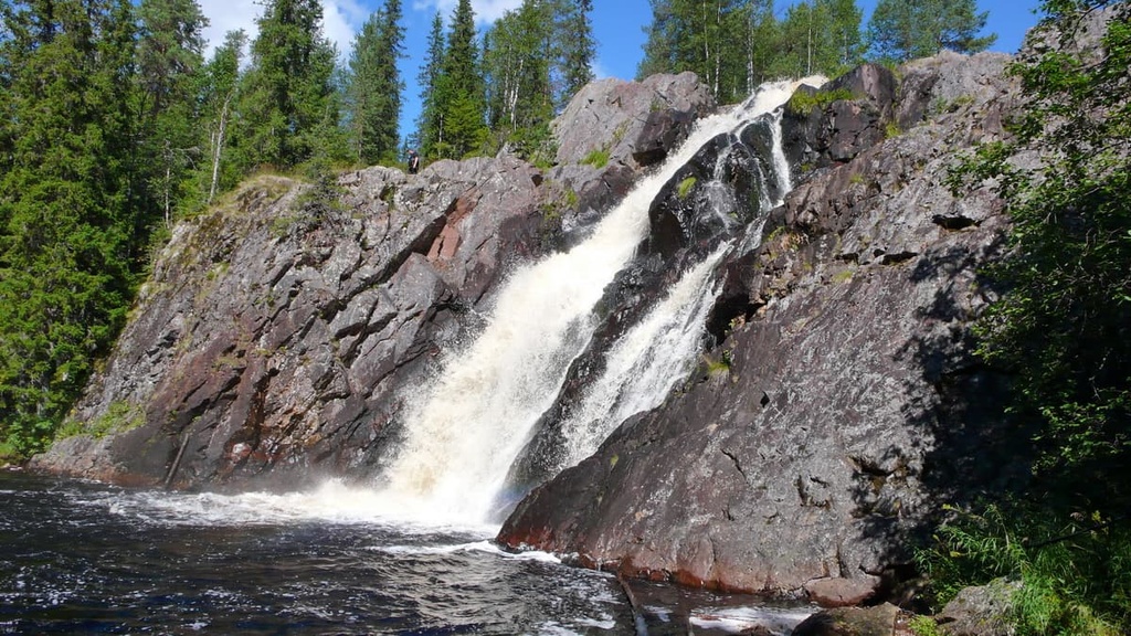
Another great destination is the Ruunaa Hiking Area, which features several trails and a system of nature trails that’s 2–31 km (1.2–19.2 mi) long, plus 40 km (24.8 mi) of snowmobile routes and 30 km (18.6 mi) of cross-country skiing trails.

In Kainuu, you can find the Kuhmo Visitor Centre “Petola” and Kajaani Castle Ruins hiking areas. You can also visit the following destinations:

North Ostrobothnia is home to a great collection of lesser-known hiking areas like Iivaara Nature Reserve. Other excellent destinations include:

The northernmost region of Finland, Lapland, is a true hiker’s paradise. Some of the many hiking areas you can find in the region include:

Some other places worth visiting in the region include the Pilke Science Center, Pulju Wilderness Area, and Sompio Strict Nature Reserve.
In addition to Ylläs Ski Resort, most other resorts in Finland are located in the Karelides. These ski resorts are the largest in the country in terms of the total length of their ski trails and their total vertical drop. All of these resorts have an average vertical drop of about 300–500 m (984–1,640 ft).
Approximately 15 of the 70 ski resorts in Finland are located in the Karelides, including:

You can find out more information about the Karelides at one of the official info points or tourist centers located in almost all major cities in the region. Here are three such visitor centers and tourist information points that you can visit in the different parts of the region of Karelia.
Lappeenranta Region Tourist Information
Brahenkatu 5, 53100, Lappeenranta, South Karelia, Finland
Monday to Saturday from 10 am to 5 pm
+3585667788
Carelicum Cultural and Tourism Center
Koskikatu 5, 80100, Joensuu, North Karelia, Finland
Monday to Friday from 10 am to 4 pm
+358132675222
Tourist Information Center of the Republic of Karelia
Karla Marx Prospect, 14, Petrozavodsk, 185035, Karelia, Russia
Monday to Friday, 10 am to 6 pm
+78142764835

When hiking in the Karelides, you can stay in one of the several basic types of accommodation that are common throughout Finland. The main ones are open wilderness huts, reservable huts, and rental huts.
In contrast to the Alpine huts, these Finnish huts are designed for 6–8 people, so they are always quite cozy. The open huts are free, and in the reservable huts, you can rent a place in a shared bunk room For rental huts, you can also rent out the entire building and pick up the key at a park’s visitor center.
The main thing to know about these huts is that the open ones are mostly located in Lapland and there are none in either the center of the country or Lakeland. Lakeland has fewer huts in general, including those that can be rented.
Hence the best option for overnight stays in the Karelides is a regular tent if you always want to be sure that you’ll have a place to stay. In Finland, you can pitch a tent anywhere you want in any of the country’s 12 wilderness areas, all of which are located in Lapland. There are also designated tent camping areas in most national parks and nature reserves.
Another option is to take your tent with you, but to try to spend the night in a hut if you have one in your natural area, especially if bad weather is in the forecast.
You can find a list of specific huts in the PeakVisor guides for individual regions, parks, and reserves in Finland.

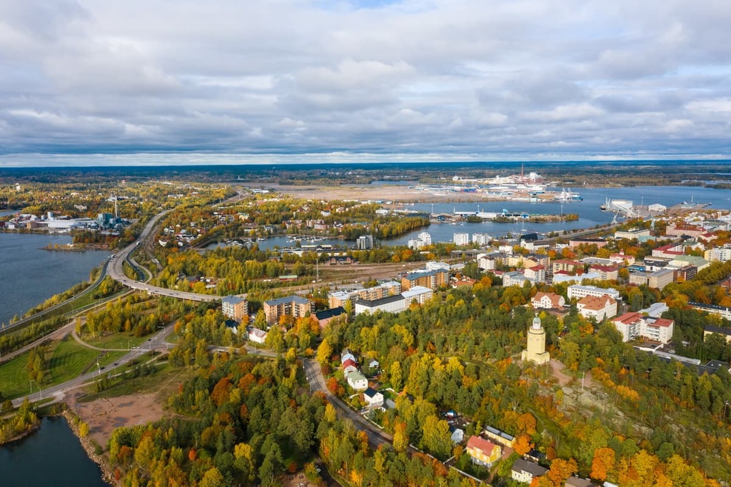
The main cities and resorts in the Karelides are the capitals of their respective regions. These include Kotka and Kouvola (yes, there are two capitals) in Kymenlaakso, Mikkeli in South Savo, Jyväskylä in Central Finland, Kajaani in Kainuu, and Oulu in North Ostrobothnia.
If you don't like big cities (though these cities are small by international standards anyway), there are smaller cities to choose from in the region. Other great places to stay in the Karelides include Kuusamo in North Ostrobothnia, Kuhmo in Kainuu, Jämsä and Äänekoski in Central Finland, and both Savonlinna and Pieksämäki, in South Savo.
I can personally recommend Pieksämäki. The town is conveniently located on the Kouvola—Kuopio railway line, so it's quick and easy to get from Pieksämäki to almost all the natural areas in Lakeland. In fact, Southern Konnevesi National Park is located only 50 km (31 mi) away from the city. You can even bike to the park from the city on the gorgeous and scenic Finnish roads.


Explore Karelides with the PeakVisor 3D Map and identify its summits.