21 Stunning Hikes near Bend Oregon
This post may contain affiliate links.

Discover the best hikes near Bend, Oregon! From challenging mountain peaks to serene alpine lakes, find your perfect hike in the heart of the Cascades.
If you are looking for an exciting hike in Bend, then you’ve come to the right spot! With its breathtaking mountain views, expansive pine forests, alpine lakes, and fascinating volcanic history, there is a reason why Bend is one of the fast-growing hubs for outdoor recreation.
When it comes to hiking, Bend has it all—and close by! From mellow hikes along the Deschutes River to long wilderness treks up in the Cascades mountains, there’s no shortage of interesting trails to explore all within a short distance from town.
Discover some of our favorite trails in the area with this guide to the best hikes near Bend. In this post, we’ll share descriptions of each trail, including distance, difficulty level, and notable features, to help you choose the trail that’s right for you.
Whether you’re looking for a quick afternoon stroll or a full-day adventure, these trails offer something for everyone, so lace up your hiking boots and get ready to explore the incredible natural beauty of Central Oregon!
Tips for hiking near Bend
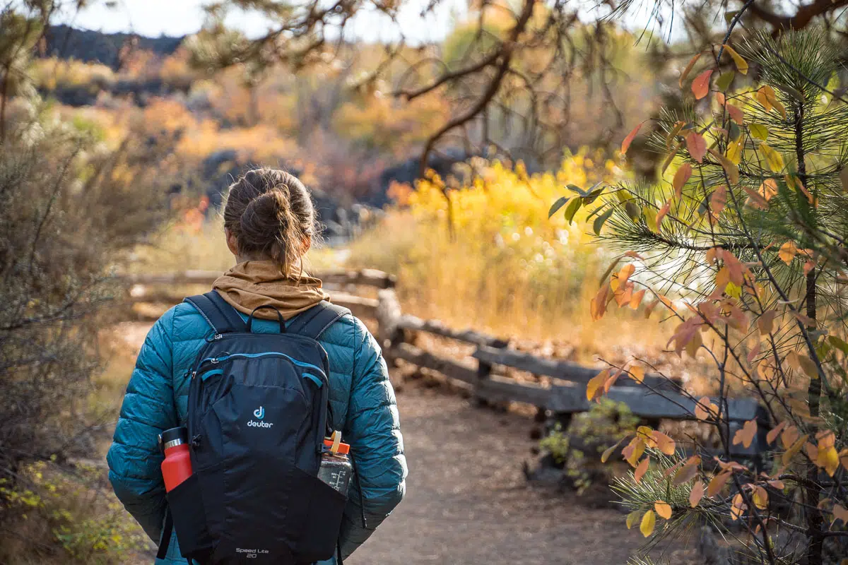
Pack the hiking essentials: It’s important to be prepared for changing weather and unexpected surprises on the trail, so you’ll want to pack all the essentials like warm layers, extra food, a headlamp, and a first aid kit. Here’s a complete checklist of hiking essentials!
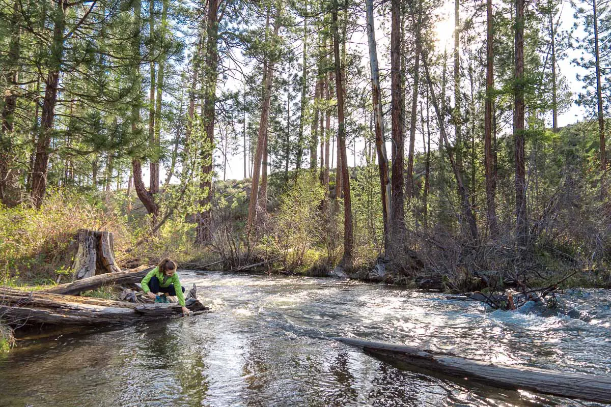
Bring plenty of water: A general rule of thumb is to drink 1 liter (32oz) of water for every two hours of hiking. However, in the summer months or on more exposed trails, you will likely want to pack more to avoid dehydration. On trails with water sources, packing a water filter (we like this one for day hikes) means you can fill up right at the source and decrease the water weight you have to carry.
Wear sturdy footwear: Leave the sandals and slip-ons at home! Many of the hikes in Bend are rocky and uneven—meaning it’s easy to slip or lose your balance. So, sturdy footwear (like trail running shoes or hiking boots) is important—and will provide better grip and support.
Sun protection: Be sure to slather up with sunscreen or wear UPF clothing for your hike. Bend is is located at a high elevation with intense sun rays, a semi-arid climate with little cloud cover, and many hiking trails offer limited shade.
Mosquitoes: Early to mid summer is mosquito season, and if your hike takes you anywhere near water, you should definitely expect lots of them! Wearing repellant can help, but if you want to jump in a lake or stream, we encourage you to rinse it off (away from the water) first to avoid polluting the water.
Parking fees: Many of the hikes near Bend are in the National Forests or Wilderness. These areas all require a pass to park—you can buy a day pass for $5 online (print it out and bring it with you), or if you have a Northwest Forests or America the Beautiful (aka the National Parks pass) annual pass, you can use those as well.
Hiking permits
The Central Cascades wilderness areas have an advanced permit system in place June 15-October 15 for its most popular trailheads, so be sure to plan in advance. We’ve indicated which trails require these permits below.
There are two opportunities to snag a day use permit: 10 days before and 2 days before. Permits become available at 7am Pacific on the Recreation.gov website—just search for the trailhead you wish to leave from.
Our Favorite Hiking Navigation App
AllTrails is one of our favorite hiking navigation apps—it provides a wealth of information including detailed trail maps and elevation profiles, recent trail reviews, and photos.
Additionally, an AllTrails+ membership offers offline maps and GPS tracking to track your progress and stay on course while hiking (it will alert you if you take a wrong turn!). You’ll also get access to “Lifeline” which allows your emergency contacts to see where you are on the trail (and alert them if you become overdue).
You can get a free 7 day trial of AllTrails+ via this link!
The best Bend Oregon hikes

Pilot Butte
Distance: 1.8 miles out & back
Elevation: 450 ft
Rating: Easy
Trailhead: Pilot Butte Trailhead
Permit required? No
A hike up Pilot Butte will give you wide views of the whole town of Bend as well as the Cascades to the west and the high desert landscape to the east. The butte itself is a 480ft cinder cone created from an extinct volcano, making Bend only one of four US cities with a volcano within its city limits.
The trail starts at the base of Pilot Butte and winds around to the top, steadily gaining elevation the whole way. Along the way you’ll be able to see trees and shrubs native to Central Oregon’s high desert like Western Juniper, Big Sagebrush, Bitterbush, and Ponderosa Pine.
At the top, you’ll get an unobstructed 360º view. Check out the interpretive signs along the stone compass, which will help you identify what you’re looking at!
This short, relatively easy hike is fairly popular and only takes an hour and change. It’s a nice way to orient yourself to the landscape if you’re visiting from out of town, or as a spot to get an outdoor workout if you live nearby!
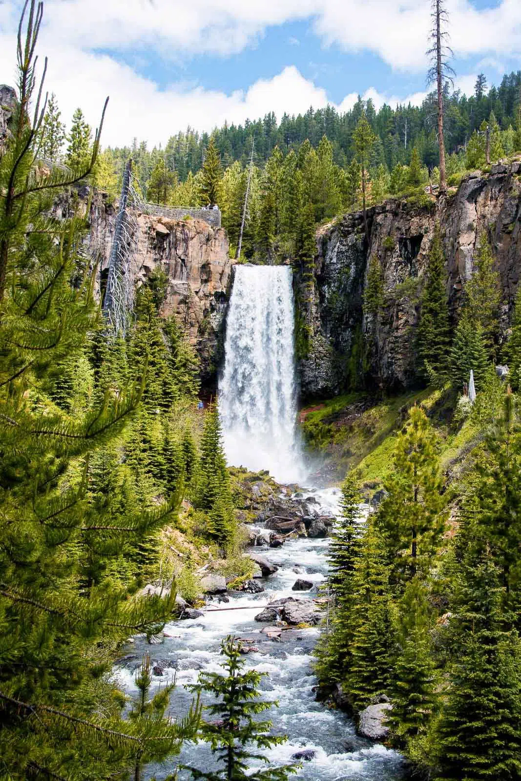
Tumalo Falls
Distance: ½ mile – 6.8 miles
Elevation: 115ft – 1,260ft
Rating: Easy-Moderate
Trailhead: Tumalo Falls Trailhead
Permit required? No, but a $5 day use pass/NW Forests/America the Beautiful annual pass is required to park
Tumalo Falls is a stunning 97 foot waterfall with a near vertical drop, making it one of the most iconic waterfalls in Central Oregon, thundering down into a valley filled with lodgepole and ponderosa pines, and dotted with stands of quaking aspen.
There are a few ways to hike near Tumalo Falls—our recommended hike is the Tumalo Falls Loop. At just under 7 miles, it will bring you to both of the Tumalo Falls overlooks as well as a number of other waterfalls as you wander through the forest (and away from the crowds that are drawn to the overlooks).
You can read more about the various routes in our full post about Tumalo Falls here.

Green Lakes Trail
Distance: 9.1 miles out & back
Elevation: 1,187 ft
Rating: Moderate
Trailhead: Green Lakes Trailhead
Permit required? Yes (6/15-10/15), can be obtained here 10 or 2 days in advance
Green Lakes is a picturesque mountain lake that sits at the base of South Sister—a scene that is definitely a reward at the end of this hike!
The Green Lakes Trail is one of our favorite hikes near Bend. The trail takes you through a stunning alpine landscape of dense forest, meadows, and alpine lakes.
The hike starts with a gradual climb along a creek. You’ll pass a few small waterfalls as you head up the trail. Eventually the trail opens up to a meadow and the first view of South Sister. The trail continues to climb, and you’ll eventually come to the first of the three Green Lakes. Each of the lakes is nestled in a bowl-shaped basin and surrounded by views of the Cascades, making for a truly spectacular sight.
The first Green Lake is the smallest of the three, just to the right of the trail. The second Green Lake is the largest and features crystal-clear water, a sandy beach, and views of South Sister. The third Green Lake is the most secluded and is tucked away in a rocky cirque. Hikers can explore around the lakes and take in the stunning mountain scenery before heading back down the trail.
Green Lakes is also one of our favorite short backpacking trip destinations. You’ll need to secure an overnight backcountry permit, which is separate from the day use hiking permit, and camp in one of the designated spots (there is a sign with a campground map as you approach the lakes).
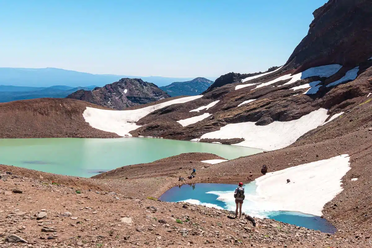
Broken Top & No Name Lake
Distance: 5.5 miles out & back
Elevation: 1,420 ft
Rating: Hard
Trailhead: Broken Top Trailhead (requires high clearance AWD/4WD to access)
Permit required? Yes (6/15-10/15), can be obtained here 10 or 2 days in advance
Other routes: You can also access this trail using the Crater Ditch Trailhead (permit required) which will increase the mileage to 7 miles round trip.
This trail, located in the Three Sisters Wilderness, is a challenging hike that leads to No Name Lake, a brilliant green glacial fed lake, at the base of Broken Top.
The main trailhead for Broken Top is at the end of an un-maintained, potholed, rocky road that definitely requires a high clearance vehicle. You can also start from the Crater Ditch Trailhead (for a 12.5 mile hike) or from the Three Creeks Snow Park (we’ve done this version—it’s worth noting that a good deal of this route goes through an exposed burn area).
The hike takes you to the Broken Top crater, where you can rest along the shore of No Name Lake. From there, you can take a quick detour to a viewpoint on the north end of the lake, where you’ll be able to see No Name Lake from above, a turquoise blue glacial tarn, the Bend Glacier, and sweeping views of the Three Sisters, Mt. Jefferson, and Mt. Washington.
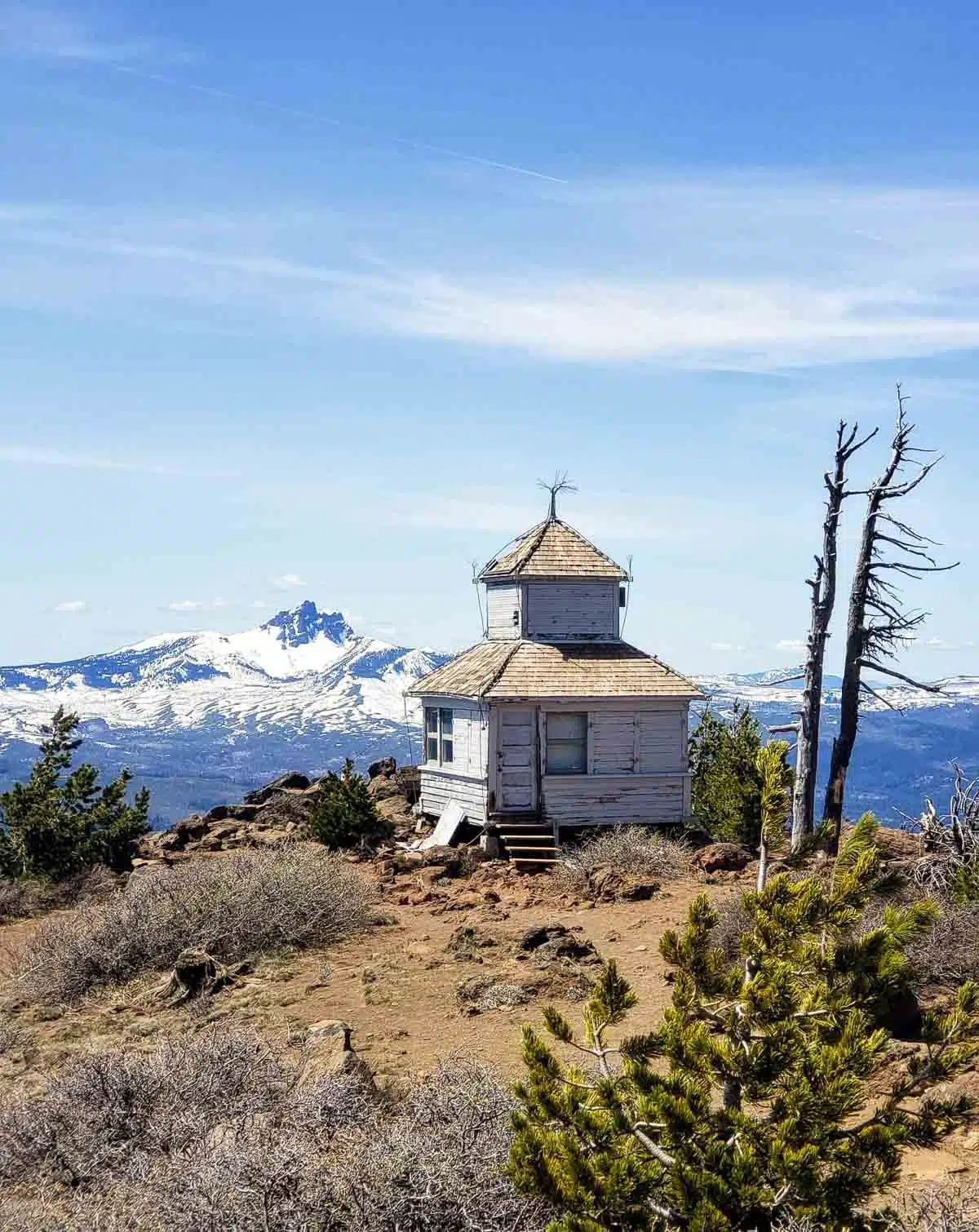
Black Butte
Distance: 3.9 miles out & back
Elevation: 1,538 ft.
Rating: Moderate-difficult
Trailhead: Black Butte Upper Trailhead
Permit required? No, but a $5 day use pass/NW Forests/America the Beautiful annual pass is required to park
The Black Butte Trail leads to the summit of Black Butte, a prominent volcanic peak that rises over 6,400 feet above sea level. The hike is moderately difficult, but the panoramic views from the top are well worth breaking a sweat for!
The trail starts with a climb through a forested area, and as you ascend, the trees thin out and the terrain becomes rocky and steep. There are several switchbacks along the way, which help to make the ascent a bit more manageable.
Once you reach the summit of Black Butte, you’ll be rewarded with stunning views of the surrounding Cascade Range. On a clear day, you will be able to see the Three Sisters, Mount Jefferson, Mount Hood, and even Mount Adams in Washington. The summit is marked by a fire lookout tower.

Sparks Lake / Ray Atkeson Loop
Distance: 2.4 mile loop
Elevation: 108 ft.
Rating: Easy
Trailhead: Ray Atkeson Trailhead
Permit required? No, but a $5 day use pass/NW Forests/America the Beautiful annual pass is required to park
The Ray Atkeson Loop at Sparks Lake is named after Ray Atkeson, a famous photographer who captured the beauty of the area in his iconic black and white photographs. This is one of the easiest hiking trails in Bend that give you a chance to experience the local mountain landscapes.
The trail starts at the Sparks Lake Day Use Area and follows a gentle, rolling path through lodgepole pines. After about a mile, the trail opens up to views of Sparks Lake, a crystal-clear alpine lake surrounded by snow-capped peaks. The trail then follows the shoreline of the lake, leading to meadows filled with wildflowers in the early summer, and crosses a small creek. The trail then climbs up to a viewpoint that offers a beautiful view of the lake and the surrounding mountains. From there, continue on the loop, which descends back down to the lake and then follows the shoreline back to the trailhead.
The Ray Atkeson Loop is an easy hike suitable for hikers of all ages and skill levels, so it is perfect for families and those who want to experience views of the Cascades without tackling a long, difficult hike. The trail is well-maintained and easy to follow, and you can expect to spend about an hour or two on the trail, depending on how often you stop to take in the scenery.

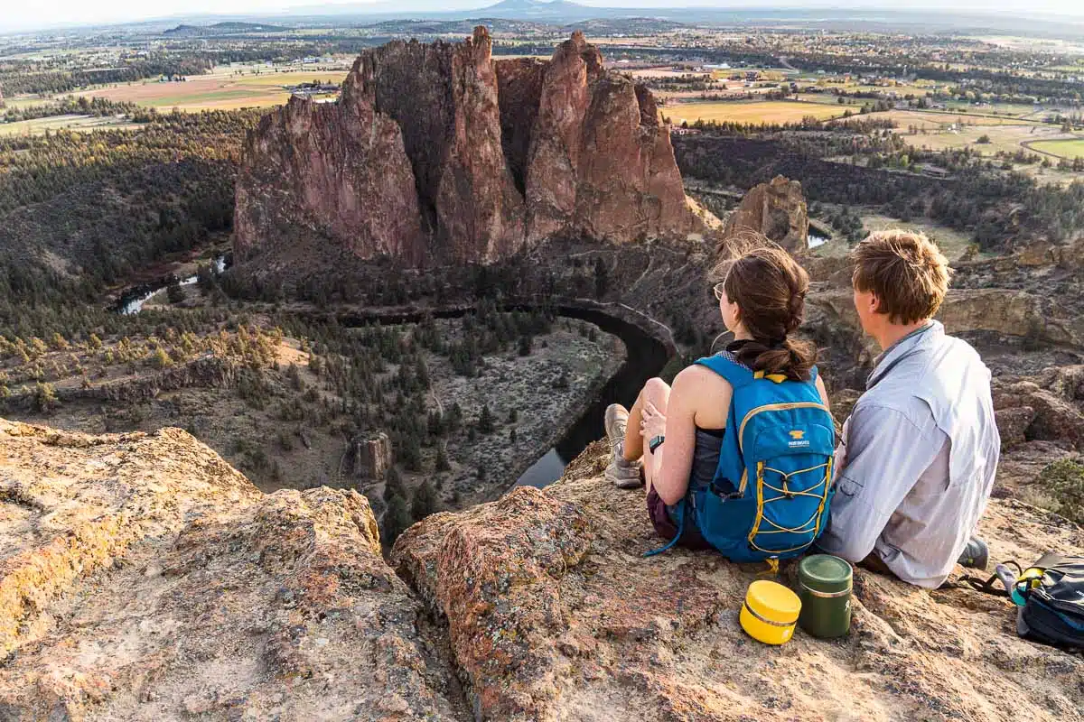
Misery Ridge Trail & River Loop (Smith Rock State Park)
Distance: 3.5 mile loop
Elevation: 948 ft
Rating: Hard
Trailhead: Smith Rock Welcome Center
Permit required? No, but you will need to purchase a State Park day pass from the kiosk in the parking lot
The Misery Ridge Trail is one of the most popular hikes in Smith Rock State Park. The trail is a 3.8-mile loop that offers panoramic views of the park’s distinctive rock formations and the surrounding high desert landscape. We’d consider it a challenging hike, with a steep ascent and descent, and rocky terrain—but the views at the top are well worth the effort.
It’s worth noting that the trail officially starts at the bottom of the canyon, which means you’ll have to hike in to, and out of, the canyon, adding a bit of mileage and some not-insignificant elevation gain to the start and end of the hike.
The actual trail starts with an immediate climb up the side of Smith Rock and up to “Misery Ridge,” a steep and rocky section that offers incredible views of the park’s iconic rock spires.
After reaching the top of Misery Ridge, continue on the loop, which offers more stunning views of the park’s unique geology, including the Crooked River Gorge and Monkey Face, a prominent rock formation that resembles a monkey’s face. The trail then descends back down, where you’ll be treated to an easy walk along the river. This section gives you a great opportunity to do some bird watching—or watch rock climbers scrambling up the sheer rock faces if that’s up your alley!

South Sister Trail
Distance: 12.4 miles out & back
Elevation: 4,986 ft
Rating: Challenging
Trailhead: Devils Lake Trailhead
Permit required? Yes (6/15-10/15), can be obtained here 10 or 2 days in advance
South Sister is the third tallest peak in Oregon, and hiking to the summit is one of the ultimate hikes near Bend! The hike is approximately 12.4 miles round-trip, with an elevation gain of over 5,000 feet. This isn’t a casual day hike, and you should be prepared for a long, full day on the trail.
The South Sister hike starts at the Devils Lake Trailhead, located on the Cascade Lakes Scenic Byway, and climbs steadily through a dense forest of lodgepole pines. As you ascend, you will pass by several alpine lakes, including Moraine Lake (this is a great spot to take a break and enjoy some energy boosting hiking snacks!). The trail then becomes steeper and more challenging, traveling through exposed rocky terrain.
As you approach the summit of the South Sister, you will pass through an otherworldly landscape of volcanic ash and pumice. The final ascent to the summit is a steep scramble up a rocky scree slope, but the effort is well worth it for the incredible panoramic views from the top. On a clear day, you can see the entire Cascade Range, including Mount Hood, Mount Adams, and even Mount Rainier in Washington.

Todd Lake Loop
Distance: 1.7 miles
Elevation: 78 ft
Rating: Easy
Trailhead: Todd Lake Trailhead
Permit required? No, but a $5 day use pass/NW Forests/America the Beautiful annual pass is required to park
The Todd Lake Trail is a great option if you want to experience the beauty of the Cascades without tackling a long, difficult hike, and would be perfect for families with younger kids.
The trailhead for the Todd Lake hike is located off the Cascade Lakes Scenic Byway, and the hike starts with a gentle climb that leads to Todd Lake, a crystal-clear lake with views of the surrounding peaks including Broken Top.
From here, you can circle the lake, or you can just hang out and relax at the day use areas along the shore. The lake is popular for fishing and swimming in the summer, so expect to have company while you are there!

Steelhead Falls
Distance: 1.2 miles out and back
Elevation: 226 ft
Rating: Easy-Moderate
Trailhead: Steelhead Falls Trailhead
Permit required? No
The hike to Steelhead Falls brings to to a 20-foot waterfall along the Deschutes River that cascades into a deep pool below—perfect for taking a quick dip on a warm summer’s day! Steelhead Falls is about 20 minutes away from Smith Rock State Park, so it’s a great add on if you’re already in the area.
The trailhead for the Steelhead Falls hike is located at the end of a dirt road, and the hike starts with a descent through a sagebrush-covered area into the canyon. Just after the half-mile mark, you’ll arrive at Steelhead Falls, where you can relax and take in the view of the falls, or jump into the pool to cool off.

Canyon Creek Meadows
Distance: 7.4 mile loop
Elevation: 1,607 ft
Rating: Moderate
Trailhead: Jack Lake
Permit required? Yes (6/15-10/15), can be obtained here 10 or 2 days in advance
Canyon Creek Meadows is one of our favorite hikes on this list! Located in the Three Sisters Wilderness, this hike will take you to a gorgeous meadow at the base of Three Fingered Jack. An additional (challenging) scramble leads up to a rim overlooking a glacial tarn.
The trail starts with a climb through a burn area—not the most scenic start to a hike, but we promise that it just gets better from here! You’ll eventually begin hiking through a shaded pine forest until you reach a creekside junction at the Lower meadow. Turn left and head towards Three Fingered Jack. After a short climb, you’ll reach Upper Canyon Creek Meadow, a gorgeous alpine basin that is filled with wildflowers in the summer. From here, you can walk the trail through the meadows, or continue on towards the base of Three Fingered Jack to scramble up to an overlook where you can see a small turquoise lake.
On the return hike, you can take a mile long detour to Wasco Lake, which is a great spot for an alpine swim.

Paulina Peak
Distance: 6.1 miles out & back
Elevation: 1,607 ft
Rating: Hard
Trailhead: Paulina Peak/Crater Rim Trailhead
Permit required? No, but there is a $5 day use fee to enter the Newberry National Volcanic Monument (or, a National Parks Pass will give you free entry)
The hike to Paulina Peak is a popular and challenging trail located in the Newberry National Volcanic Monument. The trail offers expansive views of the surrounding volcanic landscape, including the twin peaks of Paulina and East Lakes, the Big Obsidian Flow, and the Cascade Mountains in the distance.
The hike starts at Paulina Lake, and gradually climbs through a forested area for the first mile or so. After about 3.5 miles, you’ll will reach the summit of Paulina Peak, which offers stunning views of the surrounding landscape. From here, you can see the twin lakes of Paulina and East Lakes, as well as the surrounding Cascade Mountains.
It’s worth noting that there is a road that leads to the summit, so this isn’t quite the wilderness hike that you can find on other trails in the Cascades.
Shevlin Park
Distance: varies
Elevation: varies
Rating: Easy to moderate
Trailhead: The trails all start from the parking lot just passed the entry gate
Permit required? No
Shevlin Park is one of our favorite close-to-town spots for nature walks, trail runs, or an easy hike. There are a variety of trails, ranging from short and easy trails along the creek, to moderate hikes that will take you up along the canyon rim. Keep an eye out for wildlife—this is a great spot for bird watching, and we have also seen deer and river otters in the creek!
The park’s main trail is the Tumalo Creek Trail, a 4-mile loop that meanders along the banks of Tumalo Creek and passes by several small waterfalls and cascades. This is a nice walk that would be perfect for families with young kids. There are a number of picnic tables along this path, so there are lots of spots to sit and hang out for lunch or a snack as you take in the scenery.
There are also a few moderately challenging trails, including the Rim Trail and the Shevlin Loop Trail. These trails climb through rocky terrain and offer views down into the canyon.

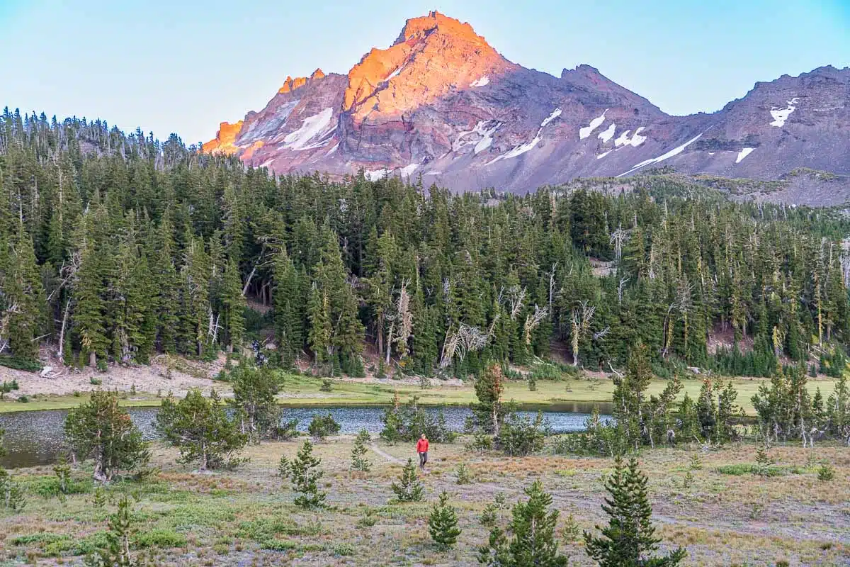
Tumalo Mountain
Distance: 4 miles out & back
Elevation: 1,423 ft
Rating: Moderate
Trailhead: Dutchman Flat
Permit required? No, but a $5 day use pass/NW Forests/America the Beautiful annual pass is required to park
The hike to Tumalo Mountain is a moderately challenging trail to the top of a cinder cone that offers outstanding views of the surrounding Cascade Mountains.
The trailhead is located off the Cascade Lakes Scenic Byway at the Dutchman Flats Sno-Park. The hike starts with a climb through a pine and hemlock forest. As hikers ascend, the trees thin out, and you’ll begin to catch views of the surrounding mountains.
Once you reach the summit, you’ll be treated to sweeping views of the surrounding landscape, including views of Mt. Bachelor, the Three Sisters, and Broken Top.
Deschutes River Trail
Distance: Varies
Elevation: Varies
Rating: Easy
Trailhead: Multiple—from town, you can start at Farewell Bend Park, or head west on Cascade Lakes Highway and access multiple other trailheads from Forest Road 41
Permit required? No, but a $5 day use pass/NW Forests/America the Beautiful annual pass is required to park at some DRT trailheads.
The Deschutes River Trail follows the Deschutes River as it winds through the Bend area. The trail gives you a chance to enjoy the river and the surrounding landscape, including basalt cliffs, forests, and unique rock formations. The trail is well-maintained and offers a variety of hiking options, ranging from short nature walks to longer, more challenging hikes. We’ve hiked this in every season and love how accessible it is year round (this is a great trail to get started with winter hiking!).
The trail can be sliced up into a number of routes of different lengths, giving you the option to “choose your own adventure”. One popular option is the section between Benham Falls to Dillon Falls, a 7-mile round-trip hike that travels between two of the many waterfalls along the Deschutes.
An easier hike can be done to Benham Falls, starting from the trailhead at the Newberry National Monument south of Bend. This version is only 1.5 miles round trip and is a good add-on to a visit to the monument.
If you want a short hiking experience without even driving out of town, head to Farewell Bend park, just minutes from downtown Bend and the Old Mill, where you can hike a portion of the Deschutes River Trail that crosses a footbridge and loops back downriver, for a scenic 3 mile loop.

Lava River Cave
Distance: 2.2 miles out and back
Elevation: 250 ft
Rating: Easy-moderate
Trailhead: Lava River Cave visitor center
Permit required? No, but a $5 day use pass/NW Forests/America the Beautiful annual pass is required to park, and during the summer months you may need a timed entry parking pass as well
The Lava River Cave is a totally unique hike through a mile-long lava tube created by an ancient lava flow. The trail inside the cave is generally easy to navigate, but be prepared for uneven terrain and limited lighting (be sure to pack a headlamp or flashlight). The cave maintains a consistent temperature of about 42 degrees Fahrenheit, which makes it super refreshing on hot days (bring a warm jacket even on the hottest of days!).
The trail starts by descending several sets of stairs into the cave and follows a metal boardwalk for the first portion. After that, you can turn around or continue through the cave on the unpaved, rocky portion of the trail. The cave intermittently narrows and opens into high caverns, eventually leading to a dead end. At this point, we recommend turning off all your lights for a minute to experience the total darkness. It’s a real trip!
The cave is open seasonally, typically from Memorial Day through September, and you’ll need to secure a timed entry pass in order to park. You should also be aware that in order to protect the resident bat population, you’ll need to wear clothes and shoes that have never been worn in other caves. This helps prevent the spread of White Nose Syndrome, which can be devastating to the bats.
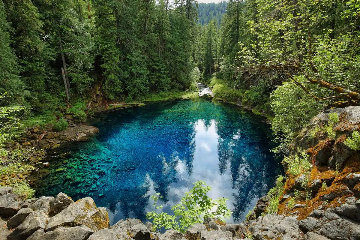
Tamolitch Blue Pool
Distance: 4.25 miles out & back
Elevation: 285 ft.
Rating: Moderate
Trailhead: Tamolitch/McKenzie River Trailhead
Permit required? No, but a $5 day use pass/NW Forests/America the Beautiful annual pass is required to park
If you’re up for a bit of a drive out of town, the hike to Tamolitch Blue Pool is not to be missed! This is an easy-moderate hike that leads to an incredible crystal-clear blue pool and seasonal waterfall.
The trail leads you through an old-growth forest along the McKenzie River. You’ll cross a few creeks using log bridges before hitting a more rugged portion of trail made of volcanic rock. After
Just after the two mile mark, you’ll come to the edge of the rocky cliffs that surround the Tamolitch Blue Pool, a mesmerizing natural pool that is fed by an underground spring (seriously, it’s like an optical illusion because of how clear it is!).
You can read more about the Tamolitch Blue Pool hike here.

Sahalie & Koosah Falls
Distance: 2.9 miles
Elevation: 360 ft
Rating: Easy
Trailhead: Sahalie Falls Viewpoint
Permit required? No, but a $5 day use pass/NW Forests/America the Beautiful annual pass is required to park
The hike to Sahalie Falls and Koosah Falls is a popular and easy trail located about an hour outside of Bend. The trail is approximately 2.6 miles round-trip and has little elevation gain, making it accessible for hikers of all skill levels, and is a great hike for families. The trail follows the McKenzie River and leads to views of the area’s two most popular waterfalls, Sahalie Falls and Koosah Falls.
The hike starts with a gentle descent through a mossy, old growth forest. After about 0.7 miles, you’ll see Sahalie Falls, a 100-foot waterfall that cascades into a large pool below.
From Sahalie Falls, the trail continues downstream to Koosah Falls, a 70-foot waterfall surrounded by basalt cliffs and unique rock formations. You’ll first be able to see the falls from above; then continue down the trail for a different vantage point before turning around and heading back.

Salt Creek Falls & Diamond Creek Falls Trail
Distance: 4 mile loop
Elevation: 784 ft
Rating: Easy-Moderate
Trailhead: Salt Creek Falls Day Use Area
Permit required? No, but a $5 day use pass/NW Forests/America the Beautiful annual pass is required to park
This hike wanders through dense evergreen forest, leading to two waterfalls and a side trail to Too Much Bear Lake. It’s a fairly short hike that has a great payoff!
From the parking lot, start with the short trail to Salt Creek Falls, which drops 286 feet into a canyon. There are multiple viewpoints that are very accessible and allow you to see the waterfall in Oregon from a few different angles.
Then, double back and head out on the Diamond Creek Falls Loop trail. The trail crosses a wooden footbridge and then travels through the forest, connecting to a few viewpoints and a side trail that leads to Too Much Bear Lake. Eventually you will come to a junction that leads to the upper and lower viewpoints of Diamond Creek Falls, a stunning waterfall that cascades over moss-covered rocks. The upper viewpoint gives you a wide angle view of the falls from above, and the lower viewpoint leads you to the base of the falls.

Scott Mountain Loop Trail
Distance: 9.1 mile loop
Elevation: 1,410 ft
Rating: Hard
Trailhead: Scott Mountain Loop Trailhead aka Benson/Tenas Trailhead
Permit required? Yes (6/15-10/15), can be obtained here 10 or 2 days in advance
Seasonal road closure: from late fall through mid-June (can change–check here first)
The Scott Mountain Loop Trail is a challenging loop that will take you to picturesque lakes, the summit of Scott Mountain, and through a number of landscapes iconic of the area including alpine meadows and a lava flow.
The trailhead for the Scott Mountain Loop Trail is located off the Santiam Pass Highway, at Scott Lake. From Scott Lake, head clockwise towards Hand Lake before beginning the ascent up Scott Mountain From this 5,350-foot peak you’ll get clear views of many Cascade peaks including Mount Jefferson, Three Fingered Jack, Mount Washington, and the Three Sisters.
Continue down from the summit, where you’ll first encounter a spur trail to the Tenas Lakes, and then to the larger Benson Lake before descending back into the Scott Lake basin.

Matthieu Lakes Trail
Distance: 6 mile loop
Elevation: 820 ft
Rating: Moderate
Trailhead: Lava Lake Camp Trailhead
Permit required? Yes (6/15-10/15), can be obtained here 10 or 2 days in advance
Seasonal road closure: from late fall through mid-June (can change–check here first)
The Matthieu Lakes Trail is a moderate hike offering views of the area’s mountain peaks and alpine lakes. There are also a number of backcountry campsites, so it’s a great option if you’re looking for an overnight backpacking trip (you’ll need a different permit for overnight stays).
After about 2 miles, you’ll reach the first lake, Lower Matthieu Lake, a stunning alpine lake perfect for taking a quick swim. From there, you can continue on the trail for another half mile to the Upper Matthieu Lake, which is situated in a scenic basin with views of several peaks, including Three Fingered Jack, North Sister, and Middle Sister.

Proxy Falls Loop Trail
Distance: 1.6 mile loop
Elevation: 147
Rating: Easy
Trailhead: Proxy Falls Trailhead
Permit required? No, but a $5 day use pass/NW Forests/America the Beautiful annual pass is required to park
Seasonal road closure: from late fall through mid-June (can change–check here first)
Proxy Falls is popular hike located in the Willamette National Forest, roughly halfway between Bend and Eugene. This “short but sweet” hike can provide a nice opportunity to get out and stretch your legs if you’re traveling between the two cities. It is approximately 1.6 miles round-trip and features open lava fields, densely covered forest, and two different waterfalls: Lower & Upper Proxy Falls.
The trailhead is located off the Old McKenzie Highway OR-242 near its junction with OR-126. The road is closed seasonally during the winter, so if you are planning a visit in spring or autumn we suggest you check to make sure the road is open. Parking at the trailhead can be quite limited and consists of shoulder parking on either side of the road. So get there early!
The trail is fairly rocky in the beginning as it traverses through exposed lava flows, before returning back to a heavily shaded forest. If you are visiting during the autumn, you might seem some spectacular fall color from the vine maple that are scattered through the flow.
The highlight of the trail are Lower Proxy falls (226 ft) and Upper Proxy falls (129 ft). Both are spectacular and well worth the visit Water flow will be highest in the spring and lowest in the autumn, although the falls run throughout the year.